
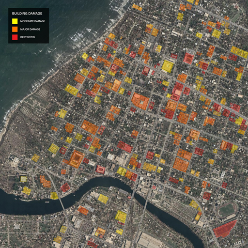
Disaster teams often have to make urgent decisions with imperfect information. A new Scientific AI approach shows how engineering knowledge, satellite-image changes, open data, and statistical imputation can work together to estimate city-scale structural damage even when post-disaster imagery is partly blocked by clouds, smoke, or other interference. For emergency planners, insurers, infrastructure owners, and recovery teams, the promise is not a magic image enhancer—it is faster, more practical disaster impact analysis when the available data is incomplete.
What problem does this new AI method solve?
It addresses one of the hardest realities in disaster response: the first satellite images after a typhoon, wildfire, flood, earthquake, or explosion may be incomplete just when responders need them most. The method, developed by a team led by Professor In Ho Cho at Seoul National University College of Engineering, uses a Scientific AI framework to estimate structural damage at city scale without relying only on perfectly clear imagery or a separate, expensive model-training stage for each event.
That matters because early damage maps shape real-world choices. If a city can identify likely areas of severe building damage sooner, agencies can prioritize rescue crews, safety inspections, road access, shelter planning, utility restoration, and recovery funding with more confidence. This is where disaster damage estimation AI becomes more than a research topic: it becomes part of the decision-support layer that helps people act under pressure.
The challenge of incomplete satellite imagery
Satellite imagery is one of the most valuable tools in modern ai for disaster management, but it is rarely perfect. Clouds, smoke, rain, shadows, debris, sensor gaps, and timing limitations can obscure exactly the areas analysts need to inspect. In the chaotic hours after a major event, waiting for ideal imagery may delay decisions, while relying on partial images may leave major blind spots.
Traditional manual assessment has its own limits. Field inspections can be dangerous, slow, and unevenly distributed across affected neighborhoods. Purely data-driven AI approaches can also struggle when they need large training datasets, high computing resources, or clear before-and-after imagery that is not available in the immediate aftermath of a disaster. The new framework responds to those constraints by treating missing image information as a statistical and engineering problem, not simply as a computer vision problem.
How engineering knowledge changes the AI damage assessment process
The key idea behind this approach is Scientific AI: artificial intelligence that incorporates domain knowledge about the physical world. Instead of asking a model to learn only from pixels, the framework combines satellite imagery with structural engineering insight and open data. That can help the system reason about damage in a way that better reflects how buildings and urban environments actually respond to extreme events.
The method uses imagery from before and after a disaster, along with publicly available data, to estimate structural damage. One important signal is image entropy, a measure of disorder or complexity in the imagery. When a built environment changes sharply after a disaster, entropy can help quantify how much the visual structure of an area has shifted.
In practical terms, this gives ai damage assessment a more interpretable foundation. The system is not just labeling damage from a photo; it is comparing conditions, measuring change, and using engineering-informed assumptions to estimate where structural harm may be concentrated. That makes the output more useful for planners who need to understand risk patterns, not just see colored pixels on a map.
A simple view of the workflow
While the underlying research is technical, the practical workflow is easier to understand when broken into steps:
- Collect pre- and post-disaster imagery. The framework compares the urban environment before and after the event.
- Add open data. Public datasets provide extra context about structures, locations, and surrounding conditions.
- Measure image change. Image entropy helps quantify how much disorder or irregularity appears after the disaster.
- Correct for missing information. Statistical imputation estimates missing damage-related values where imagery is obscured or incomplete.
- Generate city-scale estimates. The final output supports broad disaster impact analysis by identifying likely patterns of structural damage.
This workflow is valuable because it acknowledges that imperfect data is the norm in emergency conditions. Instead of discarding incomplete imagery or filling gaps with simple averages, the framework uses patterns and similarities in the available data to infer missing information more intelligently.
Why statistical imputation matters in disaster response technology
Statistical imputation is the part of the method that helps it handle missing or obscured imagery. It does not literally see through clouds or smoke. Rather, it estimates missing damage-related values from the information that remains available, supported by open data and engineering knowledge.
That distinction is important. Overstating what AI can do creates dangerous expectations, especially in emergency management. A responsible disaster response technology should make uncertainty clearer, not hide it. Imputed estimates can guide triage and planning, but they should be used alongside ground reports, aerial surveys, local knowledge, and professional engineering judgment.
This is also why the approach is relevant to ai risk assessment. Risk teams often need early estimates before all evidence is available. By combining image-change signals with data correction methods, the framework can help users reason about likely damage while still recognizing that the output is a prediction, not a final building-by-building inspection.
What makes this different from conventional AI models?
The biggest difference is that the framework is designed to work without a separate, computationally expensive training stage for each new disaster scenario. According to the research summary, it can estimate damage using pre- and post-disaster imagery and open data rather than requiring a newly assembled large-scale training dataset every time.
That could be significant for emergency use. Many AI systems perform well in controlled settings but become difficult to deploy when a disaster affects a new geography, creates unusual image conditions, or disrupts normal data pipelines. A training-free or lower-training approach may be easier to apply quickly, especially when agencies need timely estimates more than perfect retrospective analysis.
For ai disaster recovery, speed and adaptability are central. Recovery begins with knowing where to look first: which districts may need search-and-rescue support, which bridges or public buildings require inspection, which neighborhoods may face prolonged displacement, and where utility restoration may be most urgent. An AI method that can operate under messy data conditions could help narrow those priorities sooner.
Reported results and realistic expectations
The Seoul National University summary says the team validated the framework in a major typhoon damage case and found that it could estimate city-scale structural damage even when satellite data was incomplete. Notably, the reported results indicated less than 5% error when more than half of the imagery was obscured by clouds. The team also applied the framework to a major wildfire case, suggesting possible use across multiple disaster types.
Those results are promising, but they should not be read as a guarantee for every event, location, sensor, building type, or response setting. Disaster conditions vary widely. Dense urban areas, rural communities, coastal flooding, wildfire smoke, seismic collapse, and industrial explosions can all produce different visual and structural patterns. A practical disaster damage estimation AI system still needs validation, quality controls, human review, and clear communication of uncertainty.
A helpful way to interpret the technology is as a rapid estimation layer. It can point attention toward likely damage patterns, support early resource allocation, and improve situational awareness. It should not replace on-site inspections, safety assessments, or the authority of emergency officials and structural engineers.
Practical uses for emergency managers and infrastructure teams
If developed into operational tools, this kind of AI-supported damage estimation could support several high-value use cases:
- Rescue prioritization: Identify areas where severe structural damage is more likely and where teams may need to deploy first.
- Inspection planning: Help engineers and building officials decide which zones require urgent review.
- Recovery sequencing: Support decisions about debris removal, temporary housing, utility restoration, and transportation access.
- Insurance and claims triage: Provide early regional indicators that can guide more detailed assessments.
- Urban resilience planning: Reveal patterns of vulnerability that can inform future mitigation investments.
- Infrastructure management: Extend image-based analysis to aging structures or other assets where visual change may signal risk.
The common thread is not automation for its own sake. The value comes from turning fragmented data into a usable early picture of likely damage. In a crisis, even a rough but defensible estimate can help leaders move from confusion to coordinated action.
What decision-makers should look for next
For agencies and organizations evaluating AI tools for disaster work, the lesson is clear: accuracy is only one part of the equation. A useful system must also be deployable, explainable, resilient to missing data, and compatible with existing response workflows. The best tools will help analysts understand why an area is flagged, what data was missing, and how much confidence to place in the result.
Before adopting any ai for disaster management platform, decision-makers should ask:
- What data sources does the system require before and after an event?
- How does it handle clouds, smoke, shadows, or missing sensor coverage?
- Does it communicate uncertainty clearly?
- Has it been tested on disaster types and geographies similar to ours?
- Can emergency staff use the output quickly without specialized AI expertise?
- How will predictions be checked against field reports and engineering inspections?
These questions keep the focus on operational value rather than novelty. AI can accelerate analysis, but disaster response still depends on trust, coordination, and human accountability.
The bigger takeaway for AI disaster recovery
This new method points to a broader shift in disaster technology: the most useful AI systems may be those that combine data-driven pattern recognition with scientific and engineering knowledge. Incomplete satellite imagery will remain a challenge, but methods that account for missing information can make remote assessment more practical in the early stages of response.
For communities facing more complex hazards, better disaster impact analysis can support faster action and smarter recovery. The future of ai disaster recovery is not about replacing experts; it is about giving them clearer, earlier, and more context-rich evidence when every hour matters.
